
 CC-BY 4.0
Introduction
Over the past few decades, historical and cultural landmarks (i.e. physical locations, structures, sites, or areas that hold recognized significance due to their connection with past events, traditions, artistic achievements, or collective cultural identity) have faced an immediate threat, as climate change increasingly endangers cultural heritage worldwide. Extreme weather events, temperature shifts, erosion, and wildfires accelerate physical decay and foster biological threats like mold and invasive plants (Finch et al., 2021; Kapsomenakis et al., 2023; Vyshkvarkova & Sukhonos, 2023). This not only undermines the structural integrity of heritage sites but also disrupts local communities, economies, and historical memory. Addressing this growing crisis demands a shift toward proactive, sustainable strategies. Preventive preservation — anticipating and mitigating damage before it occurs— is now essential to safeguarding cultural identity and legacy.
While substantial steps have been made in addressing the effects of climate change on cultural heritage, there remains a critical need for coordinated actions, investments, and collaborative efforts regarding applications such as remote sensing. Strengthening preventive preservation measures and ensuring the sustainability of cultural heritage requires integrating monitoring systems, updating management plans, and raising awareness among stakeholders as integral components of effective adaptation strategies.
To approach these issues, the methodology adopted in this study begins with a qualitative comparative analysis of selected international and European case studies and projects. The selection criteria include:
(a) the use of remote sensing and/or digital twin technologies,
(b) a focus on preventive conservation under environmental or climate-related risks,
(c) the availability of documented outcomes or methodologies.
Through this approach, the paper aims to evaluate how different technological configurations, scales of application, and risk contexts influence the effectiveness of preventive preservation strategies, while also positioning the ARGUS project (ARGUS, 2023) within this broader landscape.
More broadly, this article explores the pivotal role of preventive preservation through the lens of remote sensing technologies. Drawing on recent projects and case studies, including the European-funded ARGUS project, the article aims to demonstrate how remote sensing, environmental monitoring, and digital twins are being integrated to safeguard remote and vulnerable heritage sites. These technologies enable real-time, non-invasive monitoring and predictive modeling, ensuring early detection of risks and informed conservation planning. The paper also discusses international frameworks and EU-funded initiatives that support the digital transformation of heritage protection. Ultimately, this work underscores the need for sustainable, technology-driven strategies to preserve cultural legacies for future generations.
The growing threat of climate change to heritage sites
Climate change (understood here as long-term shifts in climate patterns observed over recent decades) poses an escalating threat to cultural and historical heritage worldwide, manifesting through rising temperatures, shifting precipitation patterns, and extreme events—all of which pose severe risks for heritage sites. At the same time, even shorter-term climate variability, or a changing climate, can significantly affect heritage by altering the environmental conditions to which these sites were historically adapted. Cultural landmarks are especially vulnerable to flooding and storm surges, changing rainfall patterns, erosion, and weather-related damage (Yadav & Purchase, 2025). These processes contribute not only to mechanical deterioration (e.g., structural stress, cracking, and material fatigue) and biological deterioration (e.g., microbial growth, vegetation encroachment), but also to chemical deterioration, such as salt crystallization, corrosion, and pollution-driven reactions that accelerate material decay.
A particularly illustrative case is the impact of Storm Daniel in 2023, which demonstrated not only exceptional intensity but also considerable geographical reach, as it damaged a significant number of historical and archaeological sites across the Eastern Mediterranean (AL-augab & Abdulkariem, 2023). The loss of these landmarks not only erodes historical narratives but affects cultural identity and local economies rooted in heritage tourism. Indirect effects of climate change—like wildfires, altered ecosystems, and loss of traditional environmental knowledge—compound these risks, making preservation increasingly complex. International organizations like UNESCO are working to document and protect at-risk heritage sites (Reimann et al., 2018), within the framework of the UN climate action initiative for environmental protection (United Nations, n.d.). However, without decisive global efforts to curb emissions and mitigate climate impacts, the world may witness an irreversible loss of its most treasured historical landmarks
Prevention before action? The concept of preventive conservation
Adaptation is key. Rather than simply reacting to damage, we must prioritize adaptive strategies such as remote monitoring, sustainable practices, and early warning systems, all of which emphasize the importance of proactive—rather than reactive—preservation/conservation. According to the International Centre for the Study of the Preservation and Restoration of Cultural Property (ICCROM), preventive conservation involves “all measures and actions aimed at avoiding and minimizing future deterioration or loss […]. These measures and actions are indirect - they do not interfere with the materials and structures of the items. They do not modify their appearance” (ICCROM, 2026). Preserving monuments and historic buildings is essential to safeguarding and sustaining our cultural heritage, keeping it vibrant and meaningful for future generations. However, the methods employed can vary depending on whether we’re preventing damage before it happens or fixing issues after they arise. That’s where preventive preservation and traditional preservation techniques come in—they each have their own role in maintaining historic structures.
While traditional preservation techniques focus on repairing and restoring existing damages on monuments, preventive preservation is all about staying ahead of potential problems. By taking proactive steps, it is possible to slow down deterioration and reduce the need for major repairs later on. This approach helps historic monuments retain their original condition, while reducing the need for costly and intrusive interventions later. As such, preventive preservation offers a smarter, more sustainable framework for heritage care and thus may contribute to and complement the traditional restoration techniques that are always needed for the repairing and restoring monuments.
In order to apply such preventive strategies effectively, however, reliable tools for early detection and ongoing monitoring are indispensable. Advances in digital technologies now make it possible to identify risks long before they become visible to the human eye, offering new ways to safeguard vulnerable sites (Carroll & Aarrevaara, 2018). Among these technologies, remote sensing has emerged as one of the most promising approaches.
Remote sensing can be broadly defined as “the technique of obtaining information about objects through the analysis of data collected by special instruments that are not in physical contact with the objects of investigation” (Avery & Berlin, 1992). It is the process of collecting information about an object or area from a distance, typically using satellites, drones and specialized sensors. By analyzing these data, remote sensing allows for the monitoring of environmental changes, land use patterns, weather systems etc. without direct physical contact. This technology plays a crucial role in fields such as disaster management and climate science and of course, cultural heritage. Remote sensing enables us to monitor heritage sites continuously and without physical contact. It is already widely used in climate science and disaster management and is now proving essential in cultural heritage protection (Mecocci & Abrardo, 2014).
Integrated into digital twins—virtual replicas of heritage sites—sensor data enables predictive modeling and 24/7 monitoring. In this context, remote sensing provides continuous, multi-source data streams (e.g., thermal variations, surface deformation, moisture levels, and vegetation growth) that are fed into the digital twin, allowing it to simulate how the site may respond to different stressors over time. However, although satellite data has become increasingly accessible over the past few decades, studies that demand very high spatial or spectral resolution often still rely on alternative technologies such as drones, laser scanners, or radiometers, which can involve significant costs. Economic considerations may also influence access to satellite imagery, as higher-resolution datasets are often distributed through commercial providers. In addition, satellite image acquisition depends on favorable weather conditions and is limited by fixed revisit intervals that may not coincide with project needs. Nevertheless, when suitable satellite data are available, they can deliver highly reliable and valuable results for analysis and monitoring. By continuously linking the digital model to the physical condition of heritage sites, institutions gain the ability to monitor structural and environmental changes in real time. Structural conditions may include deformations, cracks, or material fatigue, while environmental conditions refer to factors such as temperature fluctuations, humidity, pollution, or ground movement. This dynamic connection enables the early detection of deterioration risks, such as material degradation or environmental threats, before they escalate (Mylonas et al., 2023). As a result, digital twins empower institutions to make timely, data-driven decisions that preserve both the physical and cultural significance of heritage assets (Dang et al., 2023; Jouan & Hallot, 2020; Kong & Hucks, 2023; Niccolucci & Felicetti, 2024).
A call for action on all levels
In the face of the rapid climate changes, organizations like UNESCO (UNESCO World Heritage Convention, n.d.a) reinforce these efforts by integrating climate adaptation into heritage conservation strategies, offering technical and policy support World Heritage Centre (2023), and collaborating on international monitoring frameworks (United Nations Office for Disaster Risk Reduction, 2015). UNESCO also develops international frameworks and collaborates with scientific and cultural institutions (UNESCO World Heritage Convention, n.d.b) to monitor the impact of climate-related factors such as rising sea levels, extreme weather events, and temperature fluctuations on historical monuments. With regard to to remote monitoring, the Updated Policy Document on Climate Action for World Heritage Centre (2023) asks States Parties and the World Heritage Centre to use the “best available knowledge”, develop climate-risk assessment tools, and scale up monitoring, feedback loops and new tools to assess climate impacts and state of conservation, thus allowing technological innovation (including remote sensing and new toolsets) to be used in adaptation, risk assessment and monitoring.
International cases
In recent decades, numerous case studies have focused on preventive conservation and cultural heritage digitization through remote monitoring and digital twins (Roby et al., 2024; Eleftheriou & Anagnostopoulos, 2022, Mitro et al., 2022; Agapiou et al., 2015; D’Agostino et al., 2014; Mecocci & Abrardo, 2014). Notable examples include the Grenada Island Digital Twin in the Caribbean (Peters, 2022) which was created to support sustainable planning and conservation of the island’s cultural and environmental resources, and the Herschel Island Digital Preservation Archive in Canada (Yukon-University of Calgary, 2022), where climate change (e.g. flooding, permafrost thawing) threatens historic sites. Alongside relocating buildings at risk, researchers are using Virtual Reality VR and 3D modeling to digitally preserve heritage, ensuring continued access for the Inuvialuit community and beyond. In the case of the ancient site of the city of Jinancheng, China, LiDAR-based remote sensing and deep learning techniques were applied for the preventive conservation and documentation of cultural heritage. By enabling precise, pixel-level identification of ancient city walls,this approach provides a powerful tool for monitoring erosion and safeguarding vulnerable archaeological sites before irreversible damage occurs (Wang et al., 2019). Likewise, the case of the Konya Slender Minaret Madrasah in Turkey highlights the role of non-invasive monitoring techniques in preventive conservation. Βy analyzing the microclimatic conditions that prevail in the monument, through wind flow and thermal performance assessments, it demonstrates how environmental data can be integrated into heritage documentation to safeguard the structural fabric and cultural significance of historic buildings (Yasa et al., 2014). At the Yongling Imperial Mausoleum, in Fushun, China, computational modeling was applied as a form of remote sensing–supported preventive conservation, using computational fluid dynamics (CFD) simulations to predict wind erosion risks that affected the building complex. By combining environmental data with virtual testing, the study demonstrates how digital tools can guide protective measures—such as strategic greening—before severe structural damage occurs (Wang et al., 2019). In the case of Löfstad Castle in Östergötland, Sweden, a parametric digital twin was developed to help preserve the historic building’s interior and collections. Researchers installed cloud-connected sensor units to continuously monitor temperature, humidity, CO₂, and other environmental conditions throughout the castle. The collected data were analyzed through a cloud-based system to identify conservation issues—such as high humidity and mold risks—and to propose energy-efficient heating and ventilation strategies for upper floors, offering a transferable model for preserving other historic buildings (Ni et al., 2025).
A comparative reading of these cases reveals recurring methodological and thematic patterns. In terms of methodological approach, the examples can be grouped into:
(a) large-scale, site-based digital twins and digital archives (e.g. Grenada, Herschel Island),
(b) high-resolution remote sensing and data-driven analysis (e.g. Jinancheng),
(c) integrated monitoring and simulation models combining environmental sensing with computational analysis (e.g. Konya, Yongling, Löfstad Castle).
In terms of scale, the applications range from territorial and landscape-level monitoring to building-specific and even material-level analysis. Regarding risk types, a common focus emerges on climate-driven and environmental threats—such as erosion, moisture, temperature fluctuations, and wind exposure—while structural vulnerabilities are addressed through continuous monitoring and predictive simulations. Across all cases, a recurring pattern is the integration of multi-source data into digital environments to support forecasting and early intervention, reflecting a broader shift from reactive to preventive conservation strategies.
Examples such as these illustrate how remote monitoring, digital modeling, and simulation-based approaches can be adopted as preventive conservation strategies across diverse cultural and environmental contexts. These cases highlight a growing recognition of the value of technology in addressing both material deterioration and broader climate-driven risks. Importantly, they demonstrate that such innovations are not confined to one region or heritage type but are adaptable to varied cultural, environmental, and social contexts. They also underscore how collaboration between local communities, researchers, and policymakers can ensure that digital tools remain not only scientifically robust but also culturally meaningful and socially inclusive. Building on these global initiatives, the following section turns to Europe, where similar methods are being adapted while also focusing on collaborative research, a shared framework of policies, standards, with strong support from the European Commission.
Actions on a European level
One of the first projects to recognize the long-term need of scientific research in addressing climate change and cultural heritage was the project Noah’s Ark (Heritage Research Hub, 2004) that resulted in the significant publication of “The Atlas of Climate Change Impact on European Cultural Heritage Scientific Analysis and Management Strategies” that underpinned EU policy of that time (Cassar et al., 2010). From that point on, the European Commission has increasingly focused on leveraging advanced technologies such as remote sensing and digital twins to protect cultural heritage monuments from the impacts of climate change. Through dedicated funding calls within programs like Horizon Europe and the Digital Europe Programme, the Commission supports innovative projects that integrate satellite data, 3D modeling, and real-time monitoring systems to assess risks and enhance conservation strategies. A notable example is the Horizon Europe Cluster 2 (Culture, Creativity and Inclusive Society) which includes topics specifically promoting the use of digital tools to safeguard cultural assets (European Commission, 2024). When viewed together, these initiatives reflect a relatively coherent policy trajectory, moving from early climate impact assessment toward the systematic integration of digital technologies for monitoring, modeling, and preventive conservation.
Projects such as STECCI (STECCI, 2023), TRIQUETRA (TRIQUETRA, 2022), THETIDA (THETIDA, 2023), and HYPERION (HYPERION, 2019), all part of the Green Cluster, exemplify how cutting-edge technologies—such as artificial intelligence, satellite data, and real-time monitoring—are being harnessed to model long-term impacts and strengthen resilience in cultural heritage conservation. The Green Cluster, a collaborative initiative under the EU Mission on Adaptation to Climate Change, aims to align climate adaptation strategies with cultural heritage protection, promoting synergies across projects that address both environmental and societal challenges (Gerakis et al., 2024). By fostering collaboration and knowledge exchange, it creates a dynamic ecosystem that not only connects related initiatives but also delivers actionable insights for evidence-based policymaking. At the same time, the clustering of these projects highlights an increasing effort to reduce fragmentation by encouraging interoperability of tools, shared methodologies, and common data frameworks, although differences in scale, scope, and technological maturity still pose challenges for full integration and comparability of results.
Moreover, a number of EU-funded projects under Horizon Europe pioneer remote and green technologies for the preventive preservation of cultural heritage. Projects like iPhotoCult (iPhotoCult, 2024), ChemiNova (ChemiNova, 2023), NERITES (NERITES, 2024), and ARGUS focus on non-destructive remote monitoring, while GoGreen (GoGreen, 2022) promotes sustainable conservation strategies. These projects have also established close collaboration, enhancing their collective impact and knowledge exchange. However, despite these synergies, certain gaps remain, particularly in the long-term standardization of data, the scalability of pilot solutions, and the consistent integration of social and community dimensions alongside technological innovation.
The ARGUS project: Non-destructive, scalable, smart monitoring of remote cultural treasures
ARGUS focuses on developing scalable digital tools for preventive preservation. It combines miniaturized sensors, a digital twin platform, and AI techniques to identify threats and optimize conservation strategies. Building on the state-of-the-art previous approaches and case studies—such as remote sensing, environmental monitoring, and simulation-based modeling—the ARGUS project advances these practices by integrating them into a unified and scalable framework. In particular, it emphasizes the interoperability of data sources, the use of low-cost sensing technologies, and the application of AI-driven analysis to support continuous, real-time risk assessment. In doing so, ARGUS moves beyond isolated or site-specific implementations, offering a more systematic and transferable protocol for preventive conservation across diverse heritage contexts.
ARGUS runs campaigns in five different pilot sites across four countries in Europe. The project, in order to define the threats faced by these sites, takes into consideration a wide range of hazards threatening the sites, organized in groups, such as earthquake (ground shaking and seismic activity that can cause structural damage), fire (both natural and human-induced events leading to partial or total loss of structures), hydrological (including flooding, rising groundwater, and water infiltration affecting materials), biodeteriogen (biological agents such as microorganisms, plants, or insects that degrade materials), atmospheric (air pollution and airborne particles causing surface erosion and chemical alteration), meteorological / climatic, chemical (temperature fluctuations, humidity, wind, and extreme weather events contributing to material stress), sea induced hazards (coastal erosion, saltwater intrusion, and wave action impacting coastal heritage sites) etc.
Across the pilot sites, the project is conducting on-site data acquisition campaigns and remote sensing tests, using both pre-existing and new environmental sensors on selected structures (such as sensors measuring temperature, humidity, air quality, and moisture levels), in order to collect and integrate both environmental and satellite data within its digital twin model. These pilot sites present a significant research challenge, since they include structures of different types, time periods that are built in largely diverse environments, sharing however one common factor: their remote location, which can benefit greatly from the implementation of remote sensing.
The Monti Lucretili upland landscape (Figure 1), situated in the Lazio region of Italy, encompasses a diverse range of natural and cultural heritage features, including ancient Roman ruins, medieval villages, and scenic landscapes (Bernardi & Farinetti, 2023; Rossi et al., 2025). However, the site is especially vulnerable to the impacts of climate change, particularly in terms of its ecological and environmental resilience. Due to their different structural nature, these monuments face an assortment of different risks factors such as ground subsidence, hydrogeological instability, soil erosion, highly invasive vegetation etc. Changes in temperature and precipitation patterns threaten the biodiversity and ecosystems of the area, compromising its long-term conservation.
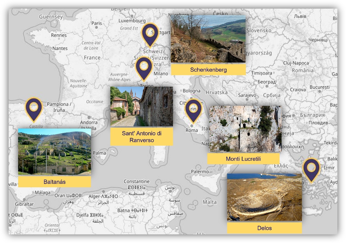
Figure 1 – A map of the ARGUS pilot case studies
The Abbey of Sant’ Antonio di Ranverso (Figure 1), located in Piedmont, Italy, is a medieval monastic complex dating back to the 12th century AD (di Pasquale & Gattiglio, 2022). Despite its historical significance, the site faces conservation challenges, worsened by climate change (Bovero et al., 2023). The gradual warming of temperatures and increased frequency of extreme weather events, such as heatwaves and heavy rainfall, pose risks to the stability and structural integrity of the abbey’s architectural elements, including its walls, roofs, and frescoes. Despite major restorations in the past decades, the complex now faces structural deteriorations and detachment of painted and unpainted plasters due to extensive capillary rise, widespread inflow of rainwater and soil detachment due to landslides.
The archaeological site of Delos (Figure 1), located in the Cyclades archipelago of Greece, is an exceptional testament to ancient Greek civilization. Designated as a UNESCO World Heritage Site, Delos is renowned for its well-preserved ruins, including temples, theater, houses, and other structures dating from the 8th century BCE to the late Roman period (UNESCO World Heritage Convention, n.d.c). It is considered a remote area due to several constraints, including the absence of a modern settlement and weather conditions that often delay or block sea connections. The primary causes of deterioration due to the coastal, windy environment are sandblasting, wind-borne aerosols, and aeolian erosion. Climate change introduces further threats such as sea-level rise, irregular and intense rainfall, fluctuations and extremes in temperature and relative humidity, desertification, and soil erosion.
The Cellar Town of Baltanás (Figure 1), located in the province of Palencia, Spain, is a unique subterranean complex consisting of interconnected wine cellars dating back to the Middle Ages. It is composed of 374 cellars structured in 6 superposed levels excavated in the ground, constituting the largest underground cellar complex in Spain (del Río-Calleja et al., 2024). However, gradual depopulation of this rural remote site poses significant risks. The increasing frequency of extreme weather events, such as heavy rainfall and flooding, poses a threat to the stability and structural integrity of the underground cellars, potentially leading to collapse or damage. Progressive abandonment and inadequate interventions have already resulted to erosions of these structures due to poor ventilation, high humidity and partial collapses or landslides.
Standing on a 200 m hill, Schenkenberg castle (Figure 1), situated in Baden-Württemberg, Germany, is a medieval fortress built by the Habsburg dynasty in the late 12th or early 13th century. Today, the site is composed by various free-standing walls and semi-collapsed towers, having lost its integrity due to historic damage (Frey, 2023). While the castle has undergone restoration efforts to preserve its historical fabric, it still remains vulnerable. Horizontal loads (e.g., wind, earthquakes),vegetation growth and freeze-thaw cycles pose threats for the structural integrity of the ruins.
The clear diversity of pilot sites raises the question: can digital twins accommodate varied contexts under a unified model? ARGUS seeks to address this challenge by exploring how a flexible, data-driven system can deliver scalable innovation in heritage preservation, through an interdisciplinary and deep collaborative approach.
ARGUS and the role of the digital twin
In the case of ARGUS, the project has developed a multimodal data management system that consists of three main data sources, which are:
The existing documentation of the pilot sites (which may include a variety of data formats) that will be filtered and transformed to the ARGUS-compatible data forms;
The multichannel satellite data;
The multimodal sensor data for area-/point-wise non-destructive measurements on monuments.
The remote sensing data include climate, weather, and pollution data with natural disaster statistics and governmental on-site measurements, thus allowing the development of a digital twin for remote built heritage, that will support the creation of complex visualisations and decision support. The ARGUS project employs a threat-to-sensor mapping methodology, where each threat “is matched with one or more sensing modalities that can detect, characterize, or anticipate its material impact” (Pavlidis et al., 2025c)
A key innovation lies in ARGUS’s use of ontologies as the semantic foundation of its digital twin. Traditional digital twins in engineering operate as closed systems focused on physical synchronization, but heritage sites embody layered cultural, social, and historical values that demand interpretability and accountability. By embedding ontology-driven reasoning, ARGUS ensures that digital twins do not merely visualize data but contextualize it—linking material conditions to cultural significance, risk factors, and policy requirements. This transforms the digital twin from a monitoring tool into a decision-support system. By combining continuous data ingestion with semantic reasoning, ARGUS creates a dynamic, risk-aware platform that bridges fragmented datasets and empowers evidence-based, sustainable management of cultural heritage.
The methodology created within the ARGUS project framework is structured through four stages:
1) threat identification: Site-specific risks—such as structural stress, salt damage, or biological growth—are identified using expert input, historical records, and site assessments.
2) risk prioritization: Since not all threats are equally urgent, they are ranked based on their potential impact and how feasible they are to monitor, taking into account factors like local climate and material vulnerability, as well as cultural signifince.
3) sensor-parameter matching: For each priority risk, suitable monitoring methods are chosen. For example, temperature and humidity can indicate moisture issues, while imaging techniques can help detect surface changes or vegetation growth.
4) deployment modeling: Finally, decisions are made on where and how to install sensors, ensuring effective monitoring while respecting the integrity of the heritage site.
The project’s digital twin will enable the intelligent management of heritage sites, ensuring their protection and sustainability for future generations. The system employed—based on the digital twin ontology named PANOPTES—supports decision-making, predictive modeling, and complex visualization—laying the groundwork for smart, sustainable management of cultural assets (Pavlidis et al., 2025a; Pavlidis et al., 2025b). The contribution of archaeologists, conservators, and cultural heritage experts is fundamental to its implementation, ensuring that the system is grounded in real-world needs and disciplinary expertise.
Conclusions: A collaborative future?
Despite their transformative potential, technology-driven approaches face significant practical and systemic limitations. Remote monitoring systems often require substantial investment in hardware, connectivity, and technical expertise—resources that many heritage sites, especially in remote or economically constrained regions, cannot easily access. The high cost of the equipment can restrict the adoption of such technologies, creating a technological divide between global heritage hubs and local or community-managed sites. Even when equipment is deployed, maintaining sensors in challenging environments—exposed to dust, heat, humidity, or political instability—can quickly become a logistical and financial burden, threatening the viability of such systems.
Beyond infrastructure, there are persistent data management and interoperability challenges. Cultural institutions frequently develop and operate within “custom-made” frameworks, each using different formats, standards, and storage systems for their data. This fragmentation limits the potential for shared learning or large-scale analysis, while also complicating the development and training of AI models that depend on harmonized datasets.
The extended digitization also raises questions regarding data ownership, access, and long-term stewardship, particularly when considering how heritage data are generated, stored, or managed by external technological providers rather than local communities. This may lead to imbalances in control and representation, potentially marginalizing local knowledge systems and cultural values. At the same time, the environmental footprint of digital infrastructures, including data storage, processing, and sensor production, should not be overlooked, as it may contradict the sustainability goals that many heritage preservation efforts actually aim to support.
Projects like ARGUS attempt to bridge this gap, aiming at long-term usability and adapting open-source concepts, while also “guarding” the data with ethical and legal criteria, in order to safeguard heritage protection (Farinetti et al., 2025). It also aims to integrate both environmental data and archaeological/historical documentation in order to provide a digital twin that represents the physical heritage site as faithfully as possible, while both data openness and data sensitivity are being balanced.
Establishing initiatives and platforms like these would enable cross-comparison of results and the creation of more accurate predictive models. Such infrastructures could follow open-science principles, ensuring that both international heritage organizations and local policy makers can contribute to and benefit from collective knowledge. Initiatives such as the European Collaborative Cloud of Cultural Heritage (ECCCH, 2024), a shared platform for heritage professionals is focused towards that direction. The platform will provide a digital environment for the exchange of knowledge and digital assets, including tools and technologies for the preservation and restoration of artifacts and monuments of cultural heritage. Through the collaboraions hosted by this initiative, the aim is to create a network for exchanging knowledge, but also to establish adaptable frameworks and tools for other cultural heritage professionals to explore and apply on their own case studies and datasets.
An interdisciplinary approach in which cultural heritage experts can collaborate, bridging technology and context to guide informed and meaningful preservation is the next step in preventive preservation. The future lies in proactive, technology-driven solutions that can only be benefited by the exchange of technical knowledge amongst experts. With tools like satellite imagery, LiDAR, and thermal scanning, experts can monitor these treasures in real time, spotting early signs of damage from humidity, temperature shifts, or structural weaknesses. When these information are reproduced in a digital twin, they do not only give the opportunity to those who create them to remotely access and predict, but can also be an example for similar case studies, allowing other experts to see the full range of potential and ask the question “will that work for me?”. In this way, they can test different preservation strategies in a digital space before making real-world decisions, detect risks early, model future scenarios, and prioritize interventions—ensuring the continued vitality of our shared cultural legacy (Libelium, 2025).
Acknowledgements
Funded by the European Union. Views and opinions expressed are however those of the author(s) only and do not necessarily reflect those of the European Union or REA. Neither the European Union nor the granting authority can be held responsible for them. The authors would also like to thank the anonymous reviewers for their valuable comments and constructive suggestions, which helped improve the quality of this manuscript. Preprint version 3 of this article has been peer-reviewed and recommended by Peer Community In Archaelogy (https://doi.org/10.24072/pci.archaeo.100682; Di Palma, 2026).
Funding
This work has been supported by the ARGUS EU project (Grant Agreement No. 101132308), funded by the European Union.
Conflict of interest disclosure
The authors declare that they comply with the PCI rule of having no financial conflicts of interest in relation to the content of the article.